September 8, 2020 Medfield - Noon Hill Reservation
Welcome to Susan's Bay Circuit Diary! This blog follows my adventures with my dog Sulu hiking the Bay Circuit Trail. To get new posts in your inbox, please subscribe (see the little "subscribe" oval above). The rest of the past posts can be found using the little menu on the left. If you are curious how this all started, go here.
Oh technology! A blessing, a curse and a crutch! (I have clearly been reading too many romance novels because this last looks like a legitimate sentence to me, but I will let it stand). Why don’t I have field notes and photos to share from this last walk in Medfield? A stupid iPhone technology issue caused by a flaky charging cable. And the story also begins with more embarrassing technology problems. Remember in previous entries how I boasted of my facility with online mapping programs and plant ID programs? Well guess what does not work without a good phone signal? Yes, all those lovely Internet aids.
One noteworthy aspect of this week’s walk was that Google Maps no longer routed me down the Mass Pike, but instead further down Route 128 (the ring road about Boston) to a later exit. If you can picture the face of a clock, where Boston is the center, the Mass Pike is the 9:00 exit that I’ve been using since May, and now I have been routed to a 7:30ish exit. I walk such short distances that it’s changes like this that make me realize I am making progress on my goal.
 |
| Noon Hill Reservation |
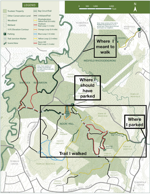
So I arrived at what Google maps told me was the Noon Hill reservation parking lot. I had saved the segment of the map on my phone showing my planned route, but there wasn’t enough detail to use it to find the trailhead. I had also saved the segment of the trail description, but there wasn’t enough specific information there either. I saw BCT blazes heading back to the main road, so I looked for blazes heading into the woods. I didn’t see the kiosk mentioned in the description, but I saw some blazes heading toward a dirt road and went in that direction. After about fifteen minutes I had that sinking feeling when you haven’t seen a blaze or marker in a while. I had to backtrack all the way to the parking lot where I found the trail took a quick jog right after the first blaze. Sulu was disappointed not to be off leash, but unfortunately this was one of the Trustees properties where although dogs are allowed off-lead, not during the pandemic. Up the trail we went, looking carefully for blazes. Somehow I over-ran another junction, but I was more cautious this time and did not go as far. The reservation's own trails were well-marked, featuring a yellow loop and a red loop, both used by the BCT. I was still pretty confused, because the directions didn’t mention the color loops, but mentioned junction numbers which I saw none of. Finally I saw a junction number, about 20 feet up in the air, 23, which was not in the directions at all - those were much lower numbers. I pressed on, knowing that at least I was on the BCT, and this mileage would contribute toward my project no matter where I was. We “summited” Noon Hill (370 feet), took a look at the view and posed Sulu so I could take pictures of him overlooking the view of the green hills beyond.
 |
| The view from Noon Hill taken by someone who did not lose his photos in an upgrade accident. By John Phelan - Own work, CC BY-SA 3.0, https://commons.wikimedia.org/w/index.php?curid=24243438 |
I ran into about five or so pairs of hikers, with no masks in sight among them. Three of them had dogs, with only one on leash.
Finally I saw a sign directing me to the parking lot (coincident with the trail). My walk would be a little shorter than planned but I would be reunited with my car. Ha ha! The joke was on me - it was a completely different parking lot, without my car! This was clearly where I should have started. I easily found the trailhead kiosk, featuring another excellent Trustees of Reservations map that I should have downloaded in advance.
Had I driven further down the road, past the lot where I parked, I would have come upon this, more official parking lot. I would have found the pond for Sulu to play in and seen all the junction numbers mentioned in the directions. Instead I stumbled upon the next part of the trail. For Sulu’s benefit, I continued back in the direction I should have gone before and gave him a water break in Holt Pond. We then continued onward to the road crossing, giving me a logical starting/stopping point for my next visit, and walked back on the dirt Noon Hill Road to the car.
I haven’t written about trail amenities much, but I did find a delicious sandwich shop in Walpole on my way home. The Good Food Store and Deli makes a good range of sandwiches including egg salad, Caprese, and cranberry walnut chicken salad. I hope I get a chance to visit them again.


Comments
Post a Comment